
Bellmore Creek through the Years
When thinking about an ecological or habitat restoration project, like at Mill Pond, Bellmore Creek, it is important to understand the historical usage of the stream and surrounding landscape. Looking back to the time of the Native Americans, the area of Bellmore Creek, near the border of Bellmore and Wantagh was likely inhabited by the Merrick and Massapeque Indians (1). It is important to note that these names given to native American “tribes” were not likely true delineations, but rather a system put on them by colonial researchers (2). Furthermore, it has been recognized that all 13 native tribes or families on Long Island spoke the Algonquin language and had similar lifestyles and dress; that it was often only a trail or stream that separated their lands (3). The abundance of streams and creeks on Long Island, and the south shore in particular, offered a wealth of shellfish and fish that were used for food for indigenous peoples. We can only guess that this wealth included plentiful runs of river herring and American eels, thus supporting several other important species of birds, fish, otters, and marine life. We recognize that these streams, like Bellmore Creek, likely had a tremendous influence on the way of life of indigenous peoples of Long island.
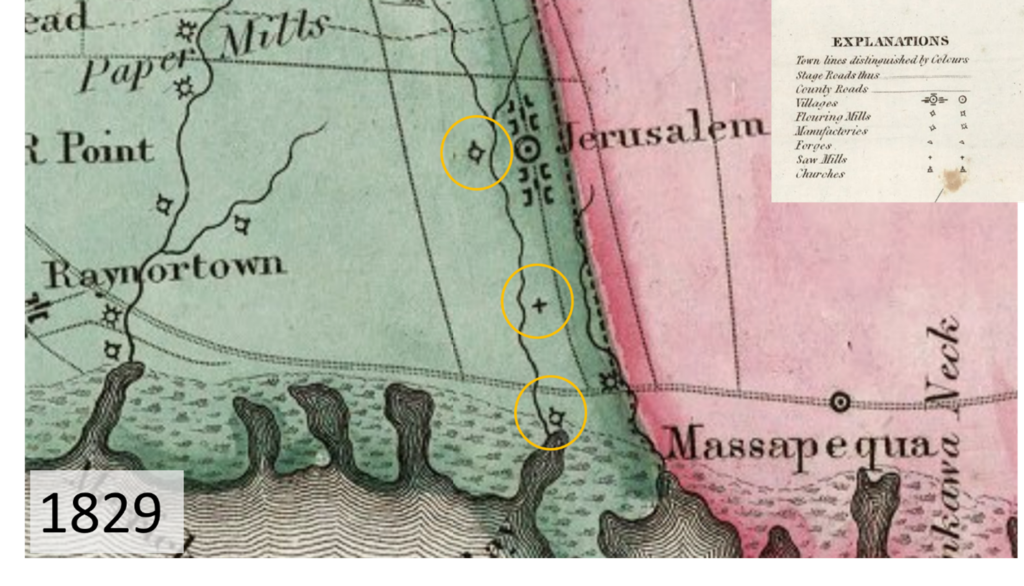
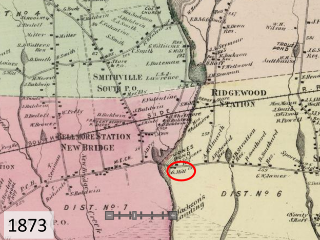
In the mid-1600’s, European settlers came down from Connecticut and started to buy land from the Merrick and Massapeque peoples in what is today parts of Wantagh and Seaford (4). Influenced by earlier Quaker settlers, the region they had inhabited was called Jerusalem, which you can see on some of the historical maps below. In the 1829 “Map of the Counties of New York, Queens, Kings, and Richmond,” we see evidence of a settlement along what is now known as Bellmore Creek (5). We also see a series of mills along the stream, two flouring mills at the northern and southernmost portion of the stream and a sawmill in between. Then, in 1867’s “40 Miles around New York,” we start to see ponding on the stream, and that the name for that pond is Jones Trout Lake (6). Moving to 1873 and the map “South part of Hempstead,” we start to see a clearer delineation of Jones Pond and the grist mill site just to the east of the pond (7).
Map of the Counties of New York, Queens, Kings, and Richmond. David Rumsey Map Collection
40 Miles Around New York. Harvard Library.

South part of Hempstead. David Rumsey Map Collection.
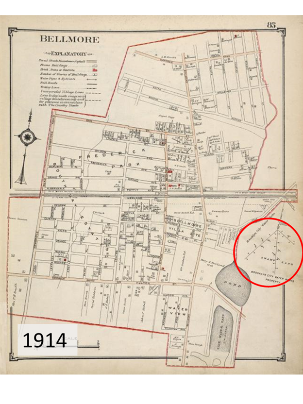
Later, as mills became obsolete, there were new needs for the streams along the south shore of Nassau County. In the early 1900’s, Brooklyn’s need for water grew and water companies started to look at streams along the south shore as a water resource. In this 1914 map of Bellmore, you can see the arrangement of Brooklyn Water Works wells to the northeast of the pond (8). Local anecdotes demonstrate that the community had concerns about the influence of the wells on the streams of the south shore. They noted that flowing water kept streams free from mud, but after the wells were implemented and the flows reduced, the stream beds transitioned to a muddy and muck-like state. They also said the streams would fill with vegetation and, when heated during summer months, release germs that were dangerous to public health. At one point the local community even asked Brooklyn Water Works to stop pumping at the Wantagh Station until the heavy rains returned.
Eventually, Brooklyn shifted away from using south shore streams as a primary water source and tapped into NYC’s water source from the Catskill and Delaware watersheds. As these streams were no longer needed for water supply, they were converted to a series of parks and parkways, like what we see today at Bellmore Creek and Wantagh Parkway (9).
Bellmore: Nassau County 1914 Long Island. Historic Map Works Residential Genealogy.
Through this brief historical analysis, we see that Bellmore Creek has been altered many times to support groups of people near and far. It is important in our effort to restore riverine connectivity at Mill Pond to understand how this system has been utilized and transformed in the past. We can use these lessons to improve the ecological health of the creek and thus support the social and economic health of the community.
Bellmore Creek and Mill Pond Today
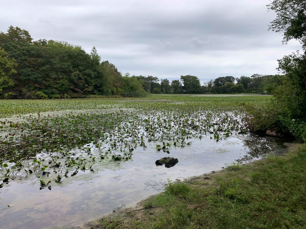
Today Mill Pond (formally known as Jones Pond), is the central feature of Nassau County’s Mill Pond Park and is used for recreation, contemplation, and waterfowl viewing. The walkway around the pond also holds a particular reverence as it is named for 9/11 first responder Adam D. Rand and there is a 9/11 memorial adjacent to the spillway.
Mill Pond currently also provides habitat to a range of recreational fish species including largemouth bass, chain pickerel, bluegill, and pumpkinseed (10). The waterway also acts as wintering and stop-over habitat for migratory waterfowl, such as buffleheads, hooded mergansers, ring-necked ducks, and more (11).
However, due to the dam and sediment filling the basin over time there is a significant problem with invasive aquatic plants in Mill Pond. Water chestnut, an invasive plant from Eurasia and Africa, forms dense mats over the surface of Mill Pond in the warmer months. The fruits have sharp spines with barbs that can wound those who may step on or handle them (12). These thick mats of vegetation can also reduce oxygen levels in the water, causing fill kills and can shade out native aquatic vegetation which many native fish, waterfowl, and insects rely on for food and shelter. Removal of water chestnut can be extremely expensive and labor-intensive, as hand-pulling and aquatic herbicides are some of the only tools for eradication.
In addition to the important ecological and social considerations of the Bellmore Creek project, we are also considering long-term economic and community resilience factors as well. The spillway was originally constructed as part of a road improvement project in the 1970’s, and thus is already an aging piece of infrastructure. Maintaining the integrity of this spillway over time can become very costly, easily running into the millions of dollars. Additionally, as sea levels rise and we see worsening storm events the spillway may not be able to handle the tidal inflow, leading to flooding of adjacent roads and parklands.
Our aim for the Bellmore Creek Fish Passage Project is to understand and integrate all the important ecological, social, and economic components of the Bellmore Creek system. It will also be crucial to comprehend how each fish passage alternative will influence the long-term health and values of the waterway.
Want to be a part of the project?
We welcome and encourage public participation in the Bellmore Creek Fish Passage project. Please reach out to Emily Hall, [email protected], for more information on how to get involved or attend an Advisory Committee meeting. You can also stay up-to-date on the project’s progress through the Bellmore Creek webpage, Facebook Page, and Instagram.
References
1. Matinecock Tribal Nations. The Indians of Long Island. Matinecock Tribal Nation. [Online] http://www.matinecocktribalnation.org/the-indians-of-long-island.html.
2. The Tribes of Long Island. Jeremy Native. [Online] [Cited: December 20, 2020.] https://www.jeremynative.com/onthissite/wiki/the-tribes-of-long-island/.
3. QNS TimesLedger. Queens’ Early History Shaped by Indians. QNS. [Online] July 9, 2003. https://qns.com/2003/07/queens-early-history-shaped-by-indians/.
4. Wantagh Local History. NY Heritage. [Online] 2020. https://nyheritage.org/collections/wantagh-local-history.
5. Map of the Counties of New York, Queens, Kings & Richmond. David Rumsey Map Collection. [Online] https://www.davidrumsey.com/luna/servlet/detail/RUMSEY~8~1~296698~90068097:Map-of-the-Counties-of-New-York,-Qu?sort=Pub_List_No_InitialSort%2CPub_Date%2CPub_List_No%2CSeries_No&qvq=q:Richmond%20County%201829;sort:Pub_List_No_InitialSort%2CPub_Date%2CPub_L.
6. 40 Miles Around New York. Harvard Library . [Online] https://iiif.lib.harvard.edu/manifests/view/ids:6938096.
7. South Part of Hempstead. David Rumsey Map Collection. [Online] https://www.davidrumsey.com/luna/servlet/detail/RUMSEY~8~1~217446~5503614:Hempstead–Long-Island-?sort=Pub_List_No_InitialSort%2CPub_Date%2CPub_List_No%2CSeries_No&qvq=q:1873%20Beers;sort:Pub_List_No_InitialSort%2CPub_Date%2CPub_List_No%2CSeries_No;lc:RUM.
8. Bellmore: Nassau County 1914 Long Island. Historic Map Works Residential Genealogy . [Online] http://www.historicmapworks.com/Map/US/2458/Bellmore/Nassau+County+1914+Long+Island/New+York/.
9. Kroessler, Jeffrey A. Brooklyn’s Thirst, Long Island’s Water: Consolidation, Local Control, and the Aquifer. Long Island History Journal. [Online] https://lihj.cc.stonybrook.edu/2011/articles/brooklyns-thirst-long-islands-water-consolidation-local-control-and-the-aquifer/.
10. Wantagh Mill Pond. NY DEC. [Online] https://www.dec.ny.gov/outdoor/24205.html.
11. Bird Observations: Mill Pond Park, Bellmore. eBird. [Online] https://ebird.org/barchart?byr=2015&eyr=2021&bmo=12&emo=2&r=L283126.
12. Water Chestnut. NY DEC. [Online] https://www.dec.ny.gov/animals/109536.html.