")

Coyote Tracker
Coyote Tracker is a community science project that engages Long Islanders in the effort to monitor the colonization of our region by Eastern Coyotes.
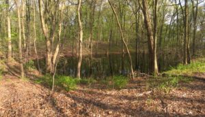
Vernal Pools
The Long Island Vernal Pool Project is an island-wide effort to identify, map and safeguard these rare habitats and the unique assemblage of wildlife they support.
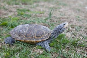
Diamondback Terrapins
Diamondback Terrapins About Diamondback Terrapins One of Long Island’s more iconic coastal species is the Diamondback Terrapin (Malaclemys terrapin), the only turtle in the world that inhabits brackish water habitats such as salt marshes, tidal creeks, and shallow bays and